Trailblazer SPOTLIGHT: Peter Oberle
Profession: Retired Public Works City Engineer
Years lived in Norfolk: 66
Three Words to Describe you: Thoughtful, Honest, Outcome-Oriented
Pronouns: He/Him
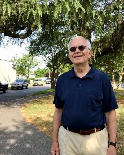
Tell us about yourself.
When I was 12 years old, my family moved from the Boston area to Norfolk, establishing my love for the Chesapeake Bay. After college, I returned to Norfolk to begin my work career as a teacher, city planner, and city engineer. I was fortunate to be involved with the planning, designing, and construction of so many municipal building projects and infrastructure projects beginning in the 1970s. Early projects included building the connection of Interstate 264 into Waterside Drive into downtown Norfolk and at the end of my employment years, working with the East Beach development.
With my personal life, when I was a bachelor, a perfect weekend day was playing tennis in the morning and sailing in the afternoon. With marriage and children, I shared my love of water with my family. There was sailing on the Elizabeth River and the
Chesapeake Bay and enjoying the Atlantic Ocean at Carova Beach, NC. Today, I find much enjoyment in walking around the neighborhoods of Norfolk and the Elizabeth River Trail.
How did you get connected to the ERT and the Foundation?
For many years, I was a resident of West Ghent and a Public Works engineer when residents of the West Ghent neighborhood developed the concept of the first phase of the Elizabeth River Trail. As part of my city employment, I was able to stay involved with the trail development, which began over two decades ago. Before the Norfolk Southern railroad tracks became the first phase of the trail, my route for travel between my home in West Ghent and the downtown YMCA was along the rails between the warehouses and over the Midtown Tunnel entrance.
Given your background, what benefits do you feel the trail has for Norfolk?
Fifty years ago, the emphasis for moving around the city was by automobile. The start of the trail helped the city consider alternative forms of travel. Roads with sidewalks could be augmented with trails for pedestrians and cyclists. The trail provides a sustainable travel path without the stress of vehicular conflicts.
Tell us about your experience being on the ERT Board.
Being on the ERT Foundation Board has introduced me to other board members who have given their time, energy, and creativity to improving the trail. The board subcommittees have planned the improvements, raised the money, overseen the implementation of the improvements, and scheduled a variety of events. I am impressed that the neighborhood-inspired trail has grown in length and amenities all along its 10.5 miles. This success has come from the Board’s ability to employ excellent, energetic staff who accomplish so many projects working closely with neighborhoods, businesses, and governmental agencies.
If you met someone who just moved to Norfolk, what would you say to get them interested In the trail?
If you want to understand much of the history of Norfolk, spend some time on the ERT. There are historic plaques all along the trail that provide information about the area over time. As you are learning, you are also exercising in the outdoor air away from the traffic of the urban environment.
What is your favorite place on the trail?
Plum Point Park is my favorite section of the trail as you can see wide areas of the Elizabeth River from the elevated pathways. There are waterfowl in the air, commercial vessels and private boats on the water, and sometimes animals in the water. The park has open space for activities, play areas for children, and benches for resting away from the bustle of the city.
The park was originally an unsightly disposal site for building debris from the old surrounding neighborhood and the Midtown Tunnel. Today, the park is surrounded by wetlands and armored banks, helping improve the rainwater flowing from the park. Plum Point Park is an excellent reuse of once discarded land on the riverfront.


